(Geography) ICSE Class X Important Questions : Geography (2002)
Disclaimer: This website is NOT associated with CBSE, for official website of CBSE visit - www.cbse.gov.in
Paper : ICSE Class X Important Questions : Geography (2002)
SECTION
- A
Attempt all questions from this Section.
Question 1
Study the extract of the Survey of India Map Sheet No. 45 D/ 7 and answer the
following questions:
(a) Give the six-figure grid reference of:
-
A 225
-
A lined well near Ganguwada. [2]
(b) Name the most important perennial source of irrigation shown on the map extract. [1]
(c) (i) What does 6r in the grid square 8495 means?
(ii) What do you mean by 20r in the grid square 8994? [2]
(d) Give two points in evidence to show that the region in the map extract has seasonal rainfall. [1]
(e) (i) What does the blue line in the Varka N indicate?
(ii) What is the general direction of the Varka N? [1]
(f) (i) What is the meaning of 1 : 50,000 printed below the map extract?
(ii) Calculate the distance in km along the cart track between Jegal in the grid square 8590 and Odhava in the grid square 8892. [2]
(g) Which part of the map is more developed in agricultural occupation? Give a reason for your answer. [2]
(h) Give the four figure grid reference of confluence of Sipu river and Varka N. [1]
-
Name two types of vegetation in the given map extract. [2]
-
What is the pattern of drainage in the grid square 8599? [1]
(k) (i) How many types of tracks are shown in the map extract? Name them.
(ii) What is the common mode of transportation in the southern part of this map? [2]
(l) What is the general pattern of settlement? Why? [2]
SECTION - B
Answer any two question from this Section.
Question 2
On the outline map of Asia, provided:
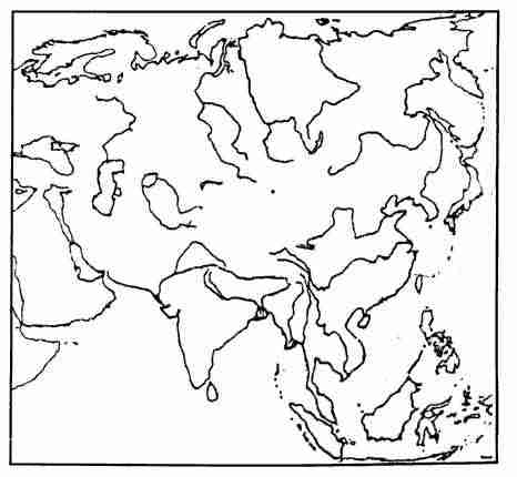
(a) Mark with a bold line and name the Urals. [1]
(b) Label the river Mekong. [1]
(c) Shade and name the Plateau of Mangolia. [1]
(d) Shade and name the Sea of Japan. [1]
(e) Shade and Name the Deccan Plateau. [1]
(f) Mark and name the Equator. [1]
(g) Label the river Yenisey. [1]
(h) Mark with a bold line and name the Caucasus. [1]
(i) Shade and name Bhutan. [1]
(j) Mark with a thick line and name the Yablonoi mountains. [1]
(k) Mark with an arrow and name Thailand. [1]
(1) Shade and name Northern Lowlands. [1]
Question 3
On the outline map of the Indian Sub-continent, provided:
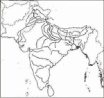
(a) Mark with a bold line the mountain range 'Satpura.' [1]
(b) Label the river Mahanadi. [1]
(c) Shade and name the Rann of Kutchh. [1]
(d) Mark and name the River Jhelum. [1]
(e) Mark with a dot and name the city of Lahore in the appropriate place. [1]
(f) Print 'TRF' in one area that has Tropical Rain Forests. [1]
(g) Mark with a dot and name Dacca. [1]
(h) Print 'COTTON’ over one area, where it is cultivated South of the Tropic of Cancer in India. [1]
(i) Print ‘I.O.’ over one area, where iron ore is mined in India. [1]
(j) Mark with a dot and name Allahabad. [1]
(k) Shade and write 'DP' over one area of Dense Population in North of the Tropic of Cancer. [1]
(l) Mark with a dot and name the biggest city on the West Coast. [1]
Question 4
(a) Why are there great variations in the climate of the Indian sub-continent? [2]
(b) Name any two local winds which blow in India and write briefly about each. [2]
(c) (i) Under what rainfall conditions are the Tropical Rain forests found?
(ii) What are the two main characteristics of the trees found in Tropical Evergreen Forests? [2]
(d) Which regions of India have Desert Vegetation? How are they adapted to climate? [1]
(e) Explain the origin of the black soil. Name two States in India, which have black soil. [2]
SECTION - C
Attempt any three questions from this Section.
Question 5
(a)
-
Name one area in India where jute is cultivated widely. [1]
-
Mention, why there is a concentration of this crop in the area mentioned by you? [1]
(b)
-
Mention a leading beverage crop of India. [1]
-
What are its requirement in terms of soil and rainfall? [1]
(c)
-
Which State is the largest producer of sugarcane in India? [1]
-
Mention the climatic conditions needed for the cultivation of this crop. [1]
(d) Name four important medicinal plants grown in India. [2]
(e) What are the two methods of cultivation of rice? Which one is known for its better yields? [2]
(f`) Explain briefly what is meant by the following terms: (i) Topping, (ii) Retting. [2]
Question 6
(a) With reference to Tata Iron and Steel Company, answer the following:
-
When and where was it set-up? [1]
-
From where does it get its supply of Iron-Ore, Coal, Limestone and Manganese? [4]
(b) Name the four centres of iron and steel in the public sector which are located in a single geographical region. With whose collaboration was each one of them set-up? [2]
(c) Why has Mumbai a large number of cotton textile units? [2]
(d) Give two reasons to show why the sugar industry has flourished in Uttar Pradesh and Bihar. [2]
(e) Give two reasons for the
following:
The silk Handloom industry is important in Mysore. [1]
Question 7
(a) With reference to Jute Industry, answer the following:
-
Name two centres of this industry in West Bengal. [1]
-
Name two major jute products. [1]
-
Mention two problems faced by this industry. [2]
(b) Name two industrial units engaged in the production of pharmaceuticals. [2]
(c) Why is fertilizer industry important for India? [2]
(d)
-
Give two reasons to explain why cottage industries are important for India's economy. [2]
-
Name the cottage industries associated with Ludhiana and Hyderabad. [2]
Question 8
(a) Name two districts of Rajasthan irrigated by the Indira Gandhi Canal. From which river its water is drawn? [2]
(b)
-
In which part of the country, wells are the most important means of irrigations? [1]
-
What are the disadvantages of well irrigation? [2]
(c) Name the four important dams in the Damodar Valley Project. [1]
(d) Where is the Rajasthan Nuclear Power Station situated? [1]
(e) What are the two main advantages of Bio-Gas? [2]
(f) Name two atomic minerals. [2]
Question 9
(a) State one advantage and one disadvantage of large dams. [2]
(b) State two ways in which canal irrigation systems can be improved in India. [2]
(c) Name two important Hydel power projects in India. [2]
(d) What is the D.V.C.? Name two of its special objectives. [2]
(e) Why have the Western Ghats great potential for hydro-electric power generation? [2]
(f) On which river is the Rihand Project located? Name an industry located near it. [2]